
Counties on Fire” employs Lincoln County residents to become involved
Dear Lincoln County Resident,

Twenty-one years ago this summer Libby came within a whisker of burning to the ground.
Longtime residents will recall that the town was
surrounded by wildfires and that – in hopes of averting disaster – the Forest Service railed fire trucks from
Cleveland, Ohio. The trucks sat on a rail siding near the Burlington Northern train station for several days.
A change in wind direction saved us – not just Libby but Troy, Trego, Rexford and
possibly Eureka. If you’ve moved here since 2000, you probably have no idea how much danger we face from the enormous accumulations of dying and dead trees standing in the Kootenai National
Forest.
The information inside Counties on Fire is designed to [1] help you understand the risks we are facing in Lincoln County, [2] encourage you to get involved in supporting Forest Service efforts to reduce our wildfire risk and [3] help you take the
practical steps necessary to protect your home, family and property.
A 2019 WUI study ranks Lincoln County in the 97th and 98th percentiles for
existing and potential wildfire risk. Our WUI area is the largest in Montana and we also have the largest percentage of primary and secondary homes within a Montana WUI. Clearly, we are living on borrowed time.
The bar graphs presented in Counties on Fire quantify annual gross growth,
mortality and net growth for the Kootenai National Forest. The Forest Service’s
Forest Inventory and Analysis [FIA] program gathers this data from survey plots
that it monitors on every national forest in Montana, including the Kootenai.
The news is frightening. 363,433,844 board feet of timber die annually on the Kootenai. Equal to 236,611 cords of wood. Converted to gallons of gasoline, 226,556,163 gallons stacked on our doorstep. Every gallon packs the explosive
power of 83 sticks of dynamite! In total, 18,804,991,529 sticks of dynamite – a
powder keg search of an ignition source: a lightning strike or an errant campfire.
The information gathered and presented in this publication reveals that the
news is even worse for all national forests in Montana combined. Net growth is
negative 1,412,884,770 billion board feet! 919,847 cords of dead wood.
Unimaginable but sadly true. We believe the Forest Service wants to do a better job of managing Montana national forests in its care, but it needs a strong showing
of public support for doing the thinning and stand tending work necessary to reduce the high risk of wildfire in our forests.
Fortunately, Congress has provided several regulatory tools that permit the
Forest Service to increase both the pace and scale of urgently needed thinning work. These include the Forest Service’s Shared Stewardship Initiative,
the Cohesive Fire Strategy, our Governor’s Focus 2.0 Initiative, Firewise, our
county’s cooperative agreement with the Forest Service and the Montana Forest
Action Plan.
Although these tools provide both hope and incentive, your strong support is critical. Inside the Counties on Fire booklet area residents have been receiving in
the mail recently, a citizen check-off card can be found which we hope you will
complete and return to our office. We will share your responses with the Montana Department of Natural Resources, Montana Fish, Wildlife and Parks, the Forest
Service and Montana’s state and federal elected officials.
A recent EPA report pegs the health hazards associated with wildfire smoke
at 12 times greater than the equivalent risk from cigarette smoke. And then there
is asbestos and the tragedy of mesothelioma.
Lincoln County is at the most important crossroad since its creation in 1909.
Reducing the wildfire risk inside our Wildland Urban Interface will bring us new wood processing infrastructure and with it, family-wage jobs that we have not
had since 2002. A bright future awaits us. Let’s seize it now!
Sincerely,
Mark Peck, Lincoln County Commission Chairman
Jerry Bennett, Commissioner
Josh Letcher, Commissioner
You can read the entire “Counties on Fire” publication online!
Go to Evergreen Magazine:
https://www.evergreenmagazine.com/lincoln-county-resources/ to open the
publication. Click on the QR Codes to follow the links for more information.
Burnt Peak & South Yaak Fire Updates, 8/2/21
The #BurntPeakFire remains at 3,305 acres and 46% contained. The #SouthYaakFire has grown to 9,290 acres and remains 10% contained.
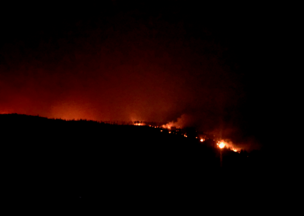
Photo of South Yaak fire taken on Saturday evening,
July 31 from Yaak River Road. (Courtesy of Chris Ekstedt)
Sunday night’s weather front was a relief from the heat but brought wetting rain only to the northeastern area of the South Yaak fire. Please remember to be careful on slick dirt roads and be on the lookout for debris falls in the burnt areas. We expect to see diminished fire behavior due to the cloud cover (less radiant heat) and higher relative humidity that will last throughout Monday.
For the Burnt Peak fire, you’ll see extensive work in the Callahan and Copper Mountain road
areas. South Yaak’s fire operations will focus along the U.S. Forest Service boundary near residences in the 17 Mile Creek area and in the area of the Kilbrennan Lake residences.
We’ll post each day’s maps as soon as we have them. There is no change in Lincoln County’s
pre-evacuation and evacuation status as of Monday morning, August 2 at 10:00 a.m.
Find complete updates, more photos, area closure orders and maps of each fire at:
South Yaak Fire → https://inciweb.nwcg.gov/incident/7696/
Burnt Peak Fire → https://inciweb.nwcg.gov/incident/7619/
Courtesy of U.S. Forest Service, Kootenai National Forest